 Registration is open for NSPECon26 in New York City, New York!
 Volunteering at NSPE is a great opportunity to grow your professional network and connect with other leaders in the field.
 Decisions at the ballot box influence policies that support engineering standards and public safety.
July/August 2018
In Focus: Emerging Technologies
Above It All
BY PATRICK INGRAHAM
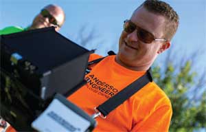 JERROD HOGAN, PICTURED ABOVE, SAYS HIS COMPANY WAS ONE OF THE FIRST IN THE MIDWEST TO OFFER PROFESSIONAL DRONE SERVICES.
As drones begin to become more and more a part of everyday life, from delivering packages to helping inspect roads and bridges, safely incorporating them into the national airspace has become one of the leading issues for those in government and those involved in facilities design and construction, like licensed professional engineers and surveyors.
Several problems still exist, however. Exactly where drone pilots can fly is still unclear in several states, creating confusion for the public. Recent easing of requirements for drone users by the Federal Aviation Administration, in conjunction with increasingly inexpensive technology advancements for drones, has made the unmanned aircraft space a lot more crowded, becoming a “wild west” of sorts.
NSPE member and licensed remote pilot Peter Glismann, P.E., says he has run into problems in his engineering and consulting work in New York after obtaining his remote pilot license in August 2017.
“I haven’t yet seen that I can parlay being a licensed engineer in addition to a drone pilot because any 16-year-old is able to take the drone test,” Glismann says. “Unfortunately, now drones have gotten so good that I’m sure unlicensed drone pilots are taking away work from FAA-licensed pilots and from licensed professional engineers.”
Similarly, Jerrod Hogan, P.L.S., vice president and principal surveyor at Anderson Engineering based in Joplin, Missouri, says that PEs and licensed professional surveyors need to get more involved with the issue and work to ensure that certain aspects of drone usage in civil engineering and surveying projects remain in the hands of those qualified and trained to deliver accurate results.
“States and professional societies, this is something we’re all going to have to get a little more serious about,” Hogan says. “There needs to be a consensus on some reasonable regulations we can promote, and frankly there are things that some folks can do better than we can and some things that only [professional engineers and surveyors] should do. As a profession, surveyors, PEs are going to have to probably get more involved in this space and start writing some smart rules that don’t just alienate everybody from the drone space but really carve out a niche that says, these are things that we’re educated in doing, that require professional training, and they matter.”
Hogan’s company began working with drones in the early 2010s when it was granted an exemption to the federal law governing the operation of unmanned aircraft. Thanks to the exemption, Anderson Engineering was one of the only engineering and surveying firms offering drone work as a professional service on surveying and civil engineering projects in the Midwest, he says.
In August 2016, however, the FAA changed its regulations, creating a separate set of rules, Part 107, to make drone regulations more uniform and to make obtaining a drone pilot license easier. Instead of requiring drone operators to be licensed pilots, now drone operators can take a 60-question online test to obtain a remote pilot license. The rules also attempted to establish regulations making commercial drone flight more practical without creating safety hazards for manually piloted aircraft. Shortly after, the FAA also set up a drone and model aircraft registry to begin standardizing and regulating the use of commercial and civil unmanned aircraft.
Sky’s the Limit in Vegas
Jerrod Hogan, P.L.S., will give a presentation on drones at NSPE’s Professional Engineers Conference in Las Vegas on July 19 at 1:30 p.m. He will discuss drone applications for engineering and surveying projects and talk about some of the drone projects he’s taken part in. He’ll also cover accuracy expectations and the significant limitations that drones still have.
While Hogan believes these steps were necessary in the regulatory process, he still sees problems with enforcement and qualification standards.
“We have worked really hard pursuing projects just to come to find out that a guy with a fresh set of Vistaprint business cards and a drone he got for Christmas ended up winning a job because he was five percent of our fee,” Hogan said. “The thing about drones is, so many people are calling themselves ‘surveyors’ or ‘engineers’ or claiming they can do topographic maps or photogrammetry, when truly, they don’t know what they don’t know.”
Hogan says that despite the influx of unlicensed pilots and amateurs, Anderson Engineering has appealed to existing clients by educating them about the benefits that drones can bring to their surveying, landscaping, and engineering projects.
“By using drones, if we can get them a product quicker, if we can help them make decisions on certain projects earlier, and with less up-front cost, we’ve been able to convince a lot of our clients that there’s a value add for them there,” Hogan says.
Cultivating business and maintaining success can also be achieved simply through the “wow” effect that drones have on the public, according to Hogan. “It’s just kind of human nature that people are always interested in whatever is the new shiny object,” he says, and drones can start a conversation that turns into a long-term business relationship.
According to Hogan, his company differentiates itself by not marketing drone services to the public, but instead to contractors, architects, developers, and others with engineering experience, who can better understand the benefits of having a drone involved in their project.
“When we market ourselves, we don’t just market ourselves as drone pilots or drone operators; we market ourselves as experienced professionals, consulting engineers and surveyors, and some of the most experienced drone pilots in this particular space,” Hogan said.
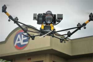 RECENT TECHNOLOGY ADVANCEMENTS HAVE MADE DRONE USE MORE EASILY ACCESSIBLE TO THE PUBLIC, BUT HAS ALSO MADE THE SPACE CROWDED, NECESSITATING UPDATED DRONE REGULATIONS.
Meanwhile, the FAA is trying to ensure drones are incorporated into the national airspace in a way that is conscious of public safety and doesn’t put piloted aircraft at risk.
In May, the administration announced that it had selected 10 local, state, and tribal governments from across the country to participate in the Unmanned Aircraft Systems Integration Pilot Program. The 10 selectees are partnering with private-sector businesses, government agencies, and outside organizations to accelerate safe unmanned aircraft systems (UAS) integration for the FAA. Among other activities, the 10 selected entities will evaluate operational concepts, including nighttime operations, flights over people and beyond the pilot’s line of sight, package delivery, and control systems reliability.
Representatives of one of those selectees, the North Dakota Department of Transportation, say that the state’s Northern Plains UAS Test Site in Grand Forks—one of the first six UAS test sites approved by the FAA—helped North Dakota stand out. NDDOT and its partners will research a variety of potential applications for drones, including emergency communications, infrastructure monitoring, and assistance in severe weather and search and rescue operations.
“Our main focus is safety,” says NDDOT UAS Integration Program Administrator Russ Bucholz. “The pilot project will generate data from the use of drones, and that data can then be used in the creation of policies and procedures. “PEs will be involved when projects are selected for UAS testing and validation,” he adds.
The plan for integration will see UAS eventually coexist with manned aircraft and operate in the same airspace. According to the Association for Unmanned Vehicle Systems International’s economic impact report, within the first three years of UAS integration more than 70,000 jobs will be created in the US with an economic impact of more than $13.6 billion. By 2025, AUVSI foresees the creation of more than 100,000 jobs with an economic impact of $82 billion.
More Featured Articles
The licensing and certification of professions and occupations are under increasing scrutiny, as legislators and regulators aim to remove barriers to the free flow of workers. Are the profession’s own longtime challenges, such as communicating the unique role of PE licensure in protecting the public, making the fight against threatening bills and regulations more difficult? »
Professional engineers often have a rare combination of leadership talent, problem-solving abilities, and knowledge of the technical matters that are such a big part of living in modern society. These attributes often shine at the office, but do PEs have a responsibility to also put them to use in their communities? »
Solving the mysteries of cancer requires the work of many experts, and engineers are among those contributing. Innovative engineers and professional engineers in a wide range of engineering disciplines are lending their know-how to a multidisciplinary offensive to stop cancer in its tracks. »
Each year, the Professional Liability Committee of NSPE’s Professional Engineers in Private Practice, in conjunction with the risk management committees of the American Institute of Architects and the American Council of Engineering Companies, conducts a survey and face-to-face interviews with representatives of companies serving the A/E professional liability insurance market. This directory and survey are designed to help get you started in selecting the experts who can assist your engineering team. »
There might be an important element missing from the current engineering curriculum: management. Many engineers find themselves in roles where they must learn how to manage other engineers on their own. Great engineering managers must have the ability to learn from their mistakes, be advocates for their teams, and possess a passion for leadership.
Professional engineers can offer more to disaster planning and recovery than design solutions. Another aspect that can’t be ignored, pre- or post-disaster, is policy. Engineers may be reluctant to get involved in this area, preferring to keep to the technical arenas where they feel most confident. But some PEs point to the need for engineers to contribute their technical knowledge to policy discussions, seeing such actions as part of the ethical responsibilities of their roles.
Pay-to-play schemes and fraudulent acts are in direct violation of the principles outlined in the NSPE Code of Ethics. When professional engineers fail to place the duty to serve ethically and in the best interest of the public welfare over political influence and financial gain, the consequences can ruin reputations and careers.